Ecotour Site - The Boyo Islands

The Boyo Islands located between Akinada and Iyonada consist of many unconnected islands spreading from east to west. In the Boyo Islands area, there are a lot of straits and channels. The complicated seabed topography created by strong currents and large-scale whirlpools support rich fishery resources of the area and provide habitats for finless porpoise. Suo-Ohshima Island is located in the western part of the Setonaikai National Park. The waters where there are the world's largest habitats for Alveopora japonica (coral) were also designated as part of the national park in 2013. Trekking in Suo-Ohshima is a lot of fun. The old trail from Jikamuro to Tononyu is an excellent trekking course. The views from the trail are just wonderful and you can enjoy seeing the beauty of the islands. We also provide an activity to visit an uninhabited island, Ohminasejima Island, to observe wild plants and birds as well as lava.
(Details of the activities, shipping routes, and ports will be decided when a new ecotour plan is provided.)
Activities
Finless porpoise watching

'Ema' watching

Sea kayaking

Experiencing a whirl pool

Coral observation

Geological viewing from a boat

History lecture

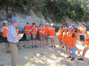
Visiting an uninhabited Island

Visiting 'Jam's Garden'

Old trail trekking

Enjoying local food

Tangerine harvesting

Suo-Ohsima Island
Suo-Ohshima Island of Yamaguchi Prefecture is the third largest island in the Seto Inland Sea. Suo-Ohsima is connected with the main island by Oshima Ohashi Bridge. The Island is well known as a tangerine-producing island thanks to a moderate climate throughout a year. As well as having a rich environment, Suo-Ohshima has abundant historical and cultural resources such as the landing monument of Siebold, the museum of battleship Mutsu, and the museum of Tsuneichi Miyamoto, one of the greatest cultural anthropologist in Japan who was the native of this island.
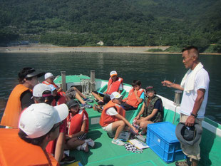
The sea around Suo-Ohsima Island is a habitat for finless porpoises that are at the top of the food chain in the Seto Inland Sea. We visit the observation points by vessel. (We go to these points based on our data, however, we are not always able to see finless porpoises.) Off the south coast, from Jikamuro to Kominasejima Island, Japan's largest coral beds (Alveopora japanica) occur. Divers dive into the sea and shoot coral images using an underwater camera and we see the live images onboard the vessel.


The old trail from Jikamuro to Tononyu is a wonderful trekking trail. History and culture are blended with nature. There are various old tales and kaidan (scary stories) associated with the trail. We can also see strange-looking rocks along the trekking course.


Kutsuna Islands

The Kutsuna Islands consist of Nakajima. Muduki, Nogutsuna, Nuwa, Tsuwaji, Futagami and Hashira islands. In the Middle Ages, the Kutsuna Islands were controlled by Kutsuna, a local ruling family, who had a suigun (naval force). On Nakajima Island there are ruins of Kuroiwa-jo castle where the suigun conducted the strategies. There is a vantage point at the mountain top of the ruins where suigun could have had a broad view from the woods. We can take the same view from the mountain top as suigun saw.
Nasake-no-seto Whirl Pool


The currents of the strait between Suo-Ohshima and Nasakejima islands are swift and complicated. The whirling of the sea in this area is called Nasake-no-seto or Kushigase Seto. The current of this whirl pool becomes 4 knots at spring tide. The current between the islands and Nasakajima Island becomes 6 knots with the spring tide as well. Also, upwelling flow is occurs in this sea area. Feel the complicated currents by eye and ear!
Nogutsuna Island

Nogutsunajima Island is located at the east end of the Kutsuna islands. The perimeter of the island is about 6 km. The life of villagers was unstable because the farmlands and fishing grounds were both small, and the villagers became migrant workers, such as carpenters or plasterers at the end of the Edo period. The peddling of kimono cloth rolls was very active from the Taisho period to the 20s of the Showa period. However, this was drastically decreased after World War II and the rapid economic growth period. Now, depopulation and aging are serious on Nogutsuna Island, and citrus production make use of the slopes and the fishery in adjacent waters support the economy of this island.
Nakajima Island
Nakajima Island has the largest population and area among the Boyo islands. The history of this island is old and aliases of this island are found in several ancient documents. From the Namboku-cho period to Sengoku period, the island was the base of Kutsuna, a local ruling family who had a suigun force. However, after the unification of Japan by Toyotomi Hideyoshi, Nakajima Island became an island of agriculture and maritime trading.
At Kuwana Shrine on Nakajima Island, more than 40 ema are preserved. The motifs of ema belong to Kuwana Shrine are mostly ships based on the island's history. Most of the ema are wooden plaques and were made during the Edo Period. It is considered that a ship motif ema represents the history of the Kutsuna family and maritime trading with wakou. Therefore, these ema are precious for research on transportation and trading in the Seto Inland Sea area.


Ohminasejima Island
Ohminasejima Island has been uninhabited for about 50 years. Before World War II, there was a schoolhouse. There was a barracks during the war, and after the war the island was a residential area for demobilized veterans. However, the island is now covered with deep forests although we can see ruins of wells and shrines. Due to the lack of guji (chief priests of Shinto shrines), rituals are no longer conducted and cultural and historical inheritance is on the verge of a crises.
On ecotours we observe plants, wild birds and lava as part of the activities.


Environmental Learning
Seto Eco conducts environmental learning for primary school students. Since 2015, we have conducted environmental learning courses focusing on finless porpoises and coral observation for 5th and 6th grade students of Kihara Primary School in Mihara City. For watching finless porpoises, we visit observation points by vessel based on porpoise location data we collected and transmitted. The aims of this project are to raise children' awareness about nature conservation and improvement through environmental learning programs, such as nature experience. Divers go into the sea and shoot coral images using an underwater camera and children see the live images on the vessel. Seeing the underwater world and ecology of corals is a unique experience that we can provide. We also conduct observations of intertidal organisms, sea plants and birds as part of the uninhabited island experience.